Wow, didn't realize it had been so long since I posted anything! Guess I had better do some updates.
I will try and find some time to update the light weight gear list with some changes I have made as well as post about an upcoming trip on the Juan de Fuca Marine Trail in August.
Tuesday, July 20, 2010
Checking in

Friday, February 20, 2009
GPS Tracker on iPhone
In preparation for the Thailand trip I traded in my HTC P4000 for an iPhone so that I can stay in touch with the family and work. I have to say it is a very cool device and the App Store has some fantastic apps.
I was looking for a way of periodically showing where I was in realtime and came across GPS Tracker from instamapper.com. Its free and seems to do what I want. If the app is left running on the iPhone it will update the site at user set intervals. Refresh the page to get my last know location.
GPS tracking powered by InstaMapper.com
Tuesday, January 6, 2009
Going to Thailand
I heard from an old friend in the second half of last year who moved to Thailand about 13 or 14 years ago. I've maintained contact with him over the years but never had the opportunity to go visit him.
After he got in touch I decided to cash in some airmiles and get out to see him (he lives in Nan, in northern Thailand). Everything is booked now for 3 weeks in March.
As well as spending some time in Bangkok, I will also be doing a 3 day sea kayak trip in Phuket and spending 3 days training to be an elephant mahout at the Elephant Conservation Center. Other than that I am also hoping to do some hikes in the hills around Nan and if time allows get to Ankor Wat in Cambodia.
I am going to be travelling light weight as March is the start of summer in Thailand so it will be very hot. I'm debating whether to take the Hennessey Hammock with me or not.
How to Rename Virtual Disk files
I ran into an issue while evaluating esXpress, a utility for imaging virtual machines (excellent program, check it out!). It looks like early versions of ESX 3.0 created identical virtual disk file names if the virtual machine used multiple datastores. This causes some snapshot operations to fail which is an issue with esXpress as it uses snapshots during the backup process. This problem has been fixed in later versions of ESX.
The solution was found in this VMWare document which gives the details on how to rename the virtual disk files.
Autocreated Printers in Citrix not Autocreating
We have had a Citrix 4.5 issue for a while now where users connecting from home through the Secure Gateway did not get their local printers autocreated in their Citrix session. For some reason it was worse for users that had USB printers. Network printers and LPT printers would connect occasionally but USB printers almost never worked. I tried mapping the local printer driver to the Citrix Universal Printer driver using the Presentation Server Console but that made no difference. The only clue was an application log when the user logged in with an Event ID of 1116.
Googling this turned up a Citrix document on the permissions needed by the Ctx_CpsvcUser account on each server. None of the suggested steps worked until I added the user account to the local Administrators group and gave the account Full Admin rights in the Citrix Access Management console.
UPDATE: This worked for awhile and then stopped again. I had to change the login account that the Citrix Print Manager service uses to Local System to get it to work again.
Geotagging Photos with a Canon SD850 IS
I've been looking into how to geotag pictures taken with my Canon SD850 using my Garmin 60 CSx GPS. My first thought was to link the two together with a USB cable and see if CHDK would add GPS support to the Canon. Unfortunately, at this time, it doesn't look like it does. It is still worth checking out though to add other cool features to your camera.
I did come across a method that has you time sync the camera and the GPS and turn on the tracking on the GPS. You go out and take your photos with the GPS on the whole time. When you get home you download the GPS track info and the photos and then use PhotoMapper to add the geotag metadata from the track to the pictures.
For extended trips, you would need to make sure that the track info was being written to the memory card in the GPS as the internal memory in the 60 CSx can only hold 1000 points.
I will try this soon and see how it works.
More details can be found here.
Friday, January 2, 2009
Blue Mountains Photos and Trip Report
Well, that was a bit of a long hiatus! Things got busy at work and home after my trip to Australia and I never found time to post an update. Time to rectify that now!
The flight to Australia was pretty uneventful. Flew from Victoria to Vancouver, Vancouver to San Francisco, San Francisco to Sydney. The flight was about 13 hours long and I managed to catch a few hours sleep thanks to the Sony NC22B noise canceling headphones I picked up before leaving.
Arrived in Sydney at about 6am and got through customs in about an hour. Picked up the car and set out to the office that I was going to using the Garmin 60CSx GPS that I had loaded with the Australia maps. Managed to get where I needed to go without too many problems. One thing I hate about driving in a new city using the GPS is that you become totally reliant on it. I could not tell you how I got from the airport to North Sydney, I just followed the prompts on the screen. I read somewhere once that the current generation of kids will never know what it is like to be lost as everything will have a GPS and location awareness built in to it. All I can say is, I hope they have plenty of batteries, as once you become dependent on a device to tell you where you are and where to go, I think that spatial processing part of your brain starts to atrophy.
Be aware when driving in Sydney that lots of stretches of the motorways and some tunnels and bridges are toll roads that use an electronic payment system. If you don't have an epass then you have to pay cash if you can. Some toll roads have no toll booths and if you don't have an epass then you have 3 days to go to a website and pay the fee. I wasn't sure if the rental car had one or not (it didn't) and just drove on. If there is a toll booth it may only be in one lane or you may have to come off at a junction, pay at the booth and then get back on the motorway. If you don't pay on the website, the rental car agency will charge you about $30 AUSD for each toll.
The drive out to the Blue Mountains was pretty uninteresting. It takes about 2 hours from Sydney to Katoomba but I stopped at the Featherdale Wildlife Park along the way to see some kangaroos, wallabies, kookaburras and other Australian animals. The Mountains aren't really mountains as we know them in Western Canada. They are more of a gradual increase in elevation until you get to a plateau and then come to these amazing sheer-sided cliff mega valleys. I stopped at Wentworth Falls and did a geocache on the path to the Empress Falls viewpoint. I continued on to Katoomba, got some lunch and then checked in at the Red Leaf Resort in Blackheath.
After dropping my bags off in the hotel room, I drove back in to Katoomba and followed a gravel road to the top of the Golden Stairs. This is a path that follows the cliff face a couple of hundred meters down in to the valley. 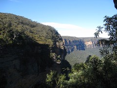
The next morning I did a short drive out to the start of the Grand Canyon loop at Evan's Lookout. This was a fantastic hike down the canyon along the narrow canyon bottom following a stream.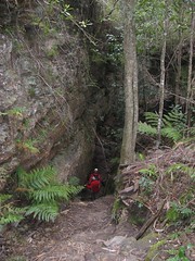
After checking out of the hotel, I spent the rest of the day geocaching in the area and then drove back to Sydney along the Bells Line of Road. This was a great drive with lots of twisties and fantastic scenery.
Unfortunately, the rest of the drip was spent working so I was stuck in Sydney for most of the time other than a day trip to the Royal National Park but this was a little disappointing in the Winter. I'm sure it would much more interesting during the summer when there should be lots of animals around.
The rest of the trip photos are here.
Tuesday, July 15, 2008
Heading Down Under Tomorrow
 A sister company based out of Sydney is having some issues with a new installation of Citrix and the parent company that owns us both wants me to go down and see what can be done. Apparently, there is a shortage of IT people with Citrix skills in Australia. Should be fun!
I've managed to bookend the week with both weekends, so on the 19th and 20th I am going to go drive out to the Blue Mountains and stay in Blackheath near Katoomba. On Saturday I'm going to walk the Golden Stairs and hike out to Ruined Castle and maybe Mt. Solitary. On Sunday I'm doing the Grand Canyon walk and then driving back to Sydney on Bells Line of Roads. Saturday the 26th I'll go down to the Royal National Park and see what I can see there.
Its wintertime in Australia so Sydney is about the same temperature as Victoria during the spring (19°C during the day, 10°C at night). Katoomba is currently about 10°C during the day and 3°C at night). So I'm having to dig out my thermals and my Thermawrap to make sure I don't freeze out my walks.
I'll put up a Flickr photostream when I get back.
Tuesday, June 10, 2008
Building a starter PC for under $300
My oldest son, Adan, has wanted to upgrade his computer for a long time. To be honest, I can't blame him. He has been using a P3-600MHz beast that I built back in 1998! I told him that if he saved up his money he could buy the pieces to make his own computer that would be be a good starting point for future upgrades for about $300 CDN. After about 6 months of saving he finally had enough and I started looking to see what I could get.
He isn't a big gamer so the only thing it had to run was Runescape and Flight Sim X. I did some research and it looked like a motherboard using the AMD 780G chipset would be a good starting point. This would support AMD processors all the way up to the new Phenoms but we could start with a dual core 4400+ for $72. The motherboard also has an integrated ATI HD3200 video card that is capable of decoding a Bluray stream even using a cheap Sempron CPU. The HD3200 can also use Hybrid Crossfire to connect to a HD3450 or a HD3470 if you want better gaming performance. This would still be nowhere as good as a dedicated 8800GT or other midrange gaming GPU but it would only cost an additional $75 vs $200.
So, in the end we got:
Biostar TForce TA780G M2+ AMD 780G mATX AM2 1PCI-E 2PCI SATA W/RAID Video Sound GBLAN Motherboard
AMD Athlon 64 X2 4400+ Dual Core Processor Socket AM2 Brisbane 2.3GHZ 2X512KB 65NM 65W Retail Box
Apex PC-373 ATX Mid Tower Case Black 4X5.25 1X3.5 4X3.5INT 400W W/ Front USB & Audio
Corsair Value Select PC2-5300 1X1GB DDR2-667 240PIN DIMM
I dug up an unused 250GB SATA HD and an unused copy of Vista Ultimate and in the end including shipping, taxes and insurance it cost $271. Not bad for a machine with a fair amount of upgrade potential and that also does everything that Adan wants to do right now.
Friday, June 6, 2008
Some tips for the West Coast Trail
Here are some quick tips if you are thinking of doing the West Coast Trail with Lightweight gear and/or a hammock in no particular order.
- I had Telus phone coverage for the entire length of the WCT. A PLB or a SPOT Personal Messanger is probably not necessary unless it makes you or your partner feel better.
- Even early in the season you can do the WCT with a lightweight gear. My suggestion would be to go from Bamfield to Port Renfrew as the trail is pretty good all the way up to KM51. I'm not a fast hiker and I don't get out and do much hiking but I still managed to do this stage in three days.
- Take a pair of lightweight shoes that you can use for wading through Michigan, Darling and Crib Creek. I left my New Balance 908s and socks on and my socks never really dried out completely even after leaving them out in the sun for an hour.
- I made the mistake of washing two pairs of my socks on day 2 which left me with only one pair of dry socks for the remainder of the trip. Merino socks are still warm and wearable when damp but it can cause blistering.
- You can easily hang a hammock at Michigan and Darling Creek. If you got creative you could probably hang off of the driftwood at TSusiat Falls. I carried on to KM29 on the beach and hung off some driftwood there. Make sure you have plenty of water as even in May there was nowhere to fill up until I got to Cribs.
- Bonilla Point has a couple of good spots for hanging a hammock and plenty of water.
- Make sure you bring a variety of food, including some fresh stuff. The highlight of my days foodwise were stopping for lunch and having some fresh hungarian salami, cheese and dried apple rings.
- Don't wash your base layer unless you are sure you can dry it completely before you need to wear it again. I made the mistake of doing this at Bonilla Point and then the fog rolled in. This meant I had to hike in my other baselayer shirt all day to Camper and then sleep in it while it was still damp. I'm sure this contributed to my cold night there.
- I only found one good spot to hang at Camper. Firewood is nonexistant here as well unless you are prepared to wade across the creek.
- If you are going to try and go around Owen point don't underestimate how long it will take you to get to the Beach Access points on the trail. On the map it looked like it was right at Camper but it took about 90 minutes to get to the first BA and onther 30 to get to the second. Make sure you factor this into your timings for the low tide.
- KM51 to KM75 are very challenging if you are wearing lightweight nonwaterproof shoes and spats. I found that I could pick my way around all of the mud holes and stay dry. However, on day 5 it rained the whole day and my feet were soaked for the whole time even without going in any of the mud. This was the worst day for my feet and it was the only time I got any significant blisters. KM70 to KM75 the trail was particularly bad. The trail has its largest elevation change and then the last 2 KM was in very bad repair. By the time I got to the end I was wiped out.
I will add more as I think of them. Good Luck!
Possible fix found MSA1500sc halting problem
Thanks to Eric at Genesis Hosting for finding a possible fix for our MSA1500sc and VMWare problem. He has had the same thing happen to him and has gotten further with HP and VMWare then I did for finding a fix.
His server hardware is a bit different than mine but the SAN and FC components are almost the same. Here are the various things that need doing to fix the problem:
- Make sure the FC HBA have the latest firmware installed
- We are both using Brocade switches, so the firmware needs to be v5.31 or higher
- Even if you only have a single controller in the MSA1500sc, upgrade to v7.00 of the firmware
- Most importantly, set the FC switch ports that your HBAs and MSA1500 are connected to to 2Gbps and unselect any unused port types. In my case I set the two MSA1500 connections to F-Type. I was unable to modify the type setting for the HP BL480p FC ports for some reason.
Eric's testing seems to indicate that the problem occurs if the SCSI Queue depth gets to high. You can view this by using the MSA1500 CLI and entering SHOW TASKSTATS.
You can change the FC port speed and type will VMs are running but you probably want to do it when there is no disk load on the SAN.
Eric also pointed out that instead of having to shut down all of the VMs and reboot the MSA1500 when the problem does occur you can go on to the CLI and enter DISABLE THIS_CONTROLLER REBOOT. If you have two controllers you would also have to do DISABLE OTHER_CONTROLLER REBOOT. This may hang or cause problems with the VMs but you should be able to reboot them without having to reboot the ESX hosts.
I have made all of the changes already except for the firmware on the Brocade switches. I have scheduled some downtime this weekend and will do the upgrade then as well as a reboot of everything and then I will leave it and see what happens.
Tuesday, May 20, 2008
West Coast Trail Photos Posted on Flickr
The photos from my West Coast Trail Trip are now up at Flickr. I'm still working on adding comments to them. I'll post a day by day point form log of the trip in the next couple of days.
Monday, May 19, 2008
West Coast Trail Trip 2008 - Day 5
- Wake up at 6am after a cold and uncomfortable night. Not sure if it is because my base layer was damp or underpad wasn't positioned correctly or what but I was pretty chilly during the night.
- Had to get up at one point to tighten the ropes as the hammock had sunk down far enough that I was bumping the log that was under me.
- Everyone else in camp is up at 6 as well so maybe it wasn't just me!
- Have a breakfast of oatmeal, pack up and am on the trail by 7:15am
- Trail is more of the same as yesterday: mud, roots and now rain!
- Feeling very tired and sore today and can't get up to speed. I have to be very deliberate going around each mud pit today to make sure I don't miss my footing.
- Glad I didn't try and go to Owen Point. It takes about an hour to get to Beach Access A and another 30 minutes to get to Beach Access B.
- Even on the boardwalks I can't seem to maintain any speed.
- Finally get to junction with Trashers Cove at around 11. Immediately the trail starts climbing up a hill.
- Start running into hikers coming the other way at about KM71. They all look happy and clean even with their gigantic packs on. Must go past about 20 people over the next 2KM.
- Phone wife to tell her I will be early and to get her to bring a change of socks, shoes and clothes as everything I'm wearing is damp or wet. Feet and socks are especially wet and soles of feet are starting to get sore.
- The last 2 KM seems to go on and on. It must take me over 90 minutes to finish. Lots of storm damage here and lots of mud. Knees are really hurting but don't want to stop to take anything.
- Finally reach the beach at KM75 at 2pm, exactly 5 days after I set out! Too tired and sore to feel anything except relief.
- Rise the buoy to signal the ferry and keep moving to stop right knee from siezing up.
- Ferry arrives after about 10 minutes and then head over to cabin to sign off the trail.
Sunday, May 18, 2008
West Coast Trail Trip 2008 - Day 4
- Woke up at 7. Another lousy nights sleep due to the surf.
- Had breakfast and was on the beach by 8:45
- Crappy sand for walking on but ploughed.
- Weather still foggy. Made mistake of leaving underwear and crew out to dry. Wetter now then when I hung them up
- Meet one of the couples from the bus out to Renfrew coming up the beach and then the two German boys from the bus.
- Finally get to end of beach section and then more ladders.
- Trail isn't too bad but is definitely the worst condition so far.
- Still make ok time to Walbaran.
- No one around so have to pull myself across again.
- Trail gets much muddier after km54 . Have a big slip around km55 and right foot goes in up to my calf.
- Lots of ladders at Logan.
- Between Logan and Cultite trail gets even worse. Slowing down to about 1.5 kmh now
- Ladders at Cultite missing last section. Have to scramble over roots and rocks on a slippery slope to get down.
- Have an audience of a bunch of teenagers having a rest on the other side of the cable car.
- More big ladders going up now and then another big stream valley to decend into on more ladders.
- Trail from here to km61 is just one big mud pit with the odd downed tree just for variety.
- Go by a group that includes two kids about 8 years old!
- Make it to camper at 4:45. Couple saw coming up the ladders at cultite arrive about an hour latter and then the teenagers.
- None of the campsites suitable for hammock so end up in the trees a bit. Weather has gotten much cooler and still foggy. Looked like it might brighten up coming into Camper but that disappeared.
- Doesn't look like i'm going to be able to go the Owen Point route. Low tide is at 7:20 so would have to leave here at 6 to have plenty of time to get around the boulders and the point.
- Should make it to Gordon River by 4 tomorrow.
Saturday, May 17, 2008
West Coast Trail Trip 2008 - Day 3
- Up at 7 and on the trail by 8
- Trail between KM29 and nitnat is ok but muddy in spots
- Get to nitnat narrows at 9:30 but have to wait under 10 until ferry operator sees me
- Have a pop at the other side and then carry on
- Nice board walk that quickly disappears into a swamp
- Follow trail around and then more boardwalk
- After about and hour or so meet a party or teenages led by a guy who like the guy who led my youth group 25 years ago
- So much trail today it is all kind of a blur
- See first bear tracks on trail just before Cheewhat and then a couple sets of them and some droppings under the Cheewhat bridge
- Stop for lunch at Cheewhat beach. Nice place. Would be great for hammock but is closed for camping due to bear.
- Meet another solo hiker at Dare beach. Water is starting to get low and ask him how far to lighthouse. He says the mud is insane around km54. Another set of hikers confirm this later on
- Getting good at mud pit hopping. Just call me dances over mud pits
- Stop at Cribs and get water and have a wash.
- First nations rangers are doing a lot of work on the trail here
- Continue on trail until Carmanagh lighthouse.
- Have to wait just after leaving beach for another group of 18 teenagers.
- Have a look around the lighthouse grounds and then move on
- Get to Chez Monique's at 4. Have a burger and a pop. No one else there except workers. Say they spend the whole season there.
- Boogie along the beach until the cable car. River is going to fast to wade so have to haul myself across. Takes whatever energy I got from the burger and pop
- Beach is gravelly and hard going. Finally get to Bonilla at 5:30
- Have another cold wash and do some laundry.
- Get a fire going and figure I will try and cut a day off tomorrow and see if I can get to Camper. This next day is supposed to be very tough.
- Hope I can get some better sleep tonight but I doubt it. Tide is coming in and the surf is loud. Fog has rolled in as well
- Strange beach. Keep thinking I hear voices but it is only the surf or the trees.
Friday, May 16, 2008
West Coast Trail Trip 2008 - Day 2

- Got 4 or 5 good hours of sleep and wake at 9
- Ron and Mark already up and packing slowly
- Decide to get ready quickly and have a cold breakfast
- Set out ahead of everyone else and walk the beach to twocowis.
- Meet another couple going south at the ladders but pass them
- Have lunch on the beach by the anchor.
- Knees have been sore again, especially my left which is odd because it is usually my right that gives me problems
- Path has been pretty good but more wet and muddy
- Get to the cable car on my own and haul self across
- Trail conditions get worse from here. Lots of storm damage.
- Make it to the beach at tsusiat by 2:30
- No one there so take some pictures, email home and work and wash socks and get some water
- Was going to stay here until after dinner and then carry on to hole in the wall but about 5 other groups arrive so pack up and head out at 5
- Possible spot to hang hammock at Hole in the Wall but meet first other solo hiker coming the other way. Compare notes with him on Spot(which has been working fine but also have Telus cell phone coverage all the way from Banfield)
- Carry on to beach acces at KM29 and find nice spot to hang hammock
- Get fire going and make dinner
- Almost a full moon tonight
- No body at all around
Thursday, May 15, 2008
West Coast Trail Trip 2008 - Day 1

Here is my notes for Day 1 of the Trip. I'll put it into more of a narrative soon.
- Left at Victoria at 6:30am
- Two other couples on the bus
- Everyone got off at the gordon River end of the trail other than two more couples that were picked up in Port Renfrew Took the logging roads over the mountains to Lake
- Cowichan and then on to Banfield
- Got there at 12 but had to wait until one for registration and intro talk
- While waiting at the bay saw a couple of hawks fishing
- Set out with Ron and Mark also from Victoria on the trail. Other european couple takes the beach to bypass the first set of ladders (second highest on the trail)
- Despite pack weighing about 30lbs due to too much food, I quickly move ahead of everyone else
- Figure i'm averaging about 3.5KM per hour.
- Trail is pleasant and pretty dry
- About 12 mud holes along way but manage to get around them with only a couple of slips
- Get to lighthouse about 20 minutes ahead of Ron and Mark
- Have lunch and have a look around
- Very nicely maintained yard and buildings. Two sat dishes
- See no one other than little boy on way out Trail quickly gets wetter and I hit a couple mud bogs that I can only go straight through.
- Get to Michigan about 5. Have to wade through creek
- No one there. Carry on to Darling
- Find a nice spot and setup hammock and undercover and pad
- Filter some water with the steripen
- Have dinner of beef stroganoff and have a chat with Ron and Mark around there fire before bed
- Have a very cozy night but don't sleep well until 5 due to sound of surf.
- Weird dreams. Wake shouting at one point thinking there is someone standing at foot of hammock.
- Knees starting to hurt

Wednesday, May 14, 2008
Bought a Spot
After talking with my wife last night about how I most likely won't be able to stay in touch while on the West Coast Trail, she left it up to me to decide if it was worth buying a SPOT Personal Tracker. I did some research and found that if used as directed it should be fine for sending the messages. A fair number of people said that it wouldn't replace a PLB for them but I can't afford both right now.
So I decided to bite the bullet and bought one today at lunch from Ralph's Radio here in Victoria (got a $10 discount as well!).
I've setup a site to share the OK messages here. When I'm back I'll give a more thorough review.
Tuesday, May 13, 2008
Starting Solo West Coast Trail Trip on May 16th
Well, everything is ready to go for my solo early season trip on the West Coast Trail using a hammock. I've chosen to go in mid May because you don't have to reserve a start date if you go between May 1st and June 14th. I've got my pack down to the lightweight class with a base weight of 6.4 Kg (14lbs 4oz) and a total pack weight of 10.3 Kg (22 lbs 11oz). Its definitely not the lightest load I've heard of for this length of a trip but it should make for a much more comfortable time than last year's aborted Juan de Fuca Marine Trail attempt with a pack weight of 27.2 Kg (60lbs)!
Even though I'm going lightweight I'm not going for any speed record. I'm planning on taking 6 days to do the entire 75 KM (46.6 miles) starting in Bamfield and ending in Port Renfrew. I'm going north to south because that was the direction I went when I was 14 and did the north half of the trail with a youth group and also by the time I get to the last couple of days, which are supposed to be the hardest, my pack will be at its lightest.
If I can get a cell phone signal, I'm going to attempt to blog from the trail. I doubt if I'll have a signal once I leave Bamfield but by the time I reach Bonilla beach at the end of day 3 I'm hoping I will have a signal from Neah Bay, across the Juan de Fuca Straight. I'll attach photos from the cell phone to start with and will replace them with real photos when I'm back and recovered.
Here is my itinerary:
May 16th - catch the West Coast Trail Express from Victoria to Bamfield
May 16th - sign on to the trail and hike to Darling campsite (14 KM)
May 17th - Darling to Hole in the Wall (14 KM)
May 18th - Hole in the Wall to Bonilla (20 KM)
May 19th - Bonilla to Logan (8 KM)
May 20th - Logan to Camper via beach at Sandstone Creek (6 KM)
May 21st - Camper to Gordon River via beach and Owen Point (13 KM)
May 21st - catch the West Coast Trail Express from Gordon River to Victoria at 4:30pm
UPDATE: I just found out that the West Coast Express only runs on odd numbered days in the shoulder season, so I'm going to move the leave day up by one day and finish on the 20th. My wife will pick me up at Gordon River.
Here are some useful links:
WCT @ i-needtoknown.com
West Coast Trail Express
The Gear I'm taking - If my current gear list changes much from this list I'll graft on a new link showing what I actually took
Tuesday, May 6, 2008
Gear dry run to Ruckle Park
With the departure date for my upcoming trip on the West Coast Trail coming up fast, I took all of the lightweight gear for a dry run on the weekend out to Ruckle Park on Saltspring Island. This was meant as a shake down trip to see how the loaded pack felt and to try out the hammock and clothes in some various types of weather.
For the most part I was very pleased with everything and with a few modifications and additions I should be set all set for the WCT.
The biggest problem I ran into was how cold I was sleeping in the hammock. The temperature on Ruckle was 7°C at night (44°F) with no wind. My campsite was right on the water. I had the Merlin -3 sleeping bag and the bivy pad in the hammock and was wearing my MEC Microweight long johns and long sleeved crew with the Wigwam merino socks. The side of me that wasn't against the bottom of the hammock was nice and warm but the other side was uncomfortably cold. I put on the Montbell Thermawrap at one point during the night but that didn't help much. I also folded the the bivy pad in half to put more insulation between me and the floor of the hammock. That helped more but as it is so narrow it was a hassle to try and stay on it. The hammock itself was very comfortable and if I had been more tired and warmer I would have had no problem getting a good nights sleep.
Since I've been back I've done some Googling to see what solutions there are to the cold problem. I'm happy to find I'm not alone. This seems to be a big gotcha with hammocks and it looks like everyone hits it unless they only warm weather camp. There are two main options to solve the cold problem, both involve adding more weight. One solution is to hang a down quilt outside the bottom of the hammock and use a sleeping bag or quilt inside. This seems to work well but is expensive and I don't think I've got time to wait for one to be shipped from the US.
The other option is to hang a cover under the hammock and put some kind of insulating material between it and the floor of the hammock. This is the route I took by ordering a Hennessy Hammock Undercover and Underpad. The reviews I've turned up see to be positive even though the open cell foam pad isn't the thick. This option is lighter than the quilt and cheaper. A bonus is that you can fine tune the padding under the hammock by adding your unused clothes, insulating layers and if needed leaves or moss. This should arrive by the end of the week so I can do another camp out at Goldstream Park to see how it works out.
The other issue I ran into was dirty clothes management. As it was chilly, I was wearing the long sleeved MEC Merino crew on the walk out to the park, in the evening while setting up and eating and to bed. I also wore it the next day on the walk back to Fulford Harbour to catch the ferry. By the time I got to Fulford I was smelling a bit rank. I had a quick wash in the sink while waiting for the ferry and changed into my short sleeved Merino t-shirt. If I was on the trail I would have washed the crew and left it to dry. However, because it was so cold in the hammock at night I feel like I need to wear a long sleeved shirt. I think the solution is to pick up another one from MEC and then I have one to wear if the other is drying. The t-shirt I can either leave or bring just in case.
Subscribe to:
Posts (Atom)
